
Tropical Storm LAURA
especiales
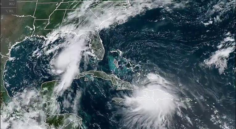
An Air Force hurricane hunter aircraft has found a slightly stronger Tropical Storm Laura just south of eastern Cuba.
At 5 p.m. Sunday, Laura was about 50 miles south of Guantanamo, Cuba.
Laura is moving toward the west-northwest near 21 mph, and this general motion with some decrease in forward speed is expected over the next couple of days.
A turn toward the northwest is forecast by Wednesday.
On the forecast track, the center of Laura will move near or over southern coast Cuba tonight and Monday, and move over the southeastern Gulf of Mexico Monday night and Tuesday.
Laura is expected to move over the central and northwestern Gulf of Mexico Tuesday night and Wednesday.
Data from an Air Force Reserve reconnaissance aircraft indicate that the maximum sustained winds are near 60 mph with higher gusts.
Little change in strength is forecast while Laura moves near the southern coast of Cuba tonight.
However, strengthening is forecast after the storm moves over the Gulf of Mexico, and Laura is forecast to become a hurricane late Tuesday or Tuesday night.
Tropical-storm-force winds extend outward up to 140 miles from the center.
A Tropical Storm Warning is in effect for:
- Entire coast of the Haiti
- Inagua and the Ragged Islands in southeastern Bahamas
- Little Cayman and Cayman Brac
- Cuban provinces of Camaguey, Las Tunas, Holguin, Guantanamo, Santiago de Cuba, Granma, Ciego De Avila, Sancti Spiritus, Villa Clara, Cienfuegos, Matanzas, Mayabeque, La Habana, Artemisa, Pinar del Rio, and the Isle of Youth
A Tropical Storm Watch is in effect for:
- Florida Keys from Craig Key to Key West and the Dry Tortugas


Add new comment