
Hurricane Matthew expected to cause ‘devastating impacts' in Haiti
especiales
Hurricane Matthew is poised to bring catastrophic flooding to Haiti and the Dominican Republic later Monday, according to Severe Weather Center 9 meteorologist Brian Shields.
“Dangerous Matthew is battering Haiti right now. They are going to deal with up to 40” of rain which will lead to catastrophic flooding and overall devastation. We need to pay very close attention to Matthew as well. It will be in the Bahamas midweek, and close to our east coast late week. It is still too early to tell exactly how close it will get to us in Central Florida,” said Severe Weather Center 9 meteorologist Brian Shields.
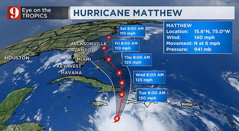
Matthew continues as a very strong Category 4 Hurricane with maximum sustained wind speeds of 130 mph.
The storm is currently moving north at 6 mph.
Hurricane hunters have been constantly investigated Matthew and although the system seems to be showing signs of slight weakening, it is expected Matthew will maintain its intensity.
With its current track, the storm looks like it will stay about 300 miles away from the Florida peninsula.
If the forecast stays on track, the entire eastern part of Florida can expect high wave action and gusty winds.
Beach erosion is likely along the eastern coast of Florida.
Matthew is a massive storm, measuring more 700 miles from north to south, and more than 600 miles east to west, and would cover the entire state of Florida
There has been virtually no wind shear over the Central Caribbean which is helping the system keep its strength.
Tropical-storm-force winds extend more than 195 miles and hurricane-force winds about 32 miles from its center.
Matthew is set to gradually gain some more speed Monday morning, passing between Jamaica and Haiti sometime late Monday or early Tuesday morning.
@GWaldenWFTV #HurricaneMatthew new forecast cone out, now moving north slowly, still a powerful category 4. #WFTV
Matthew is set to gradually gain some more speed Monday morning, passing between Jamaica and Haiti sometime late Monday or early Tuesday morning.
Watch: Tom Terry: Hurricane Matthew Sunday update
"It's not uncommon for powerful storms to fluctuate in intensity," meteorologist George Waldenberger said. "It may be a sign the eye is going through an eyewall replacement cycle."
Matthew continues to be a massive hurricane, covering more than 700 miles.
Trackers still have it pushing between Jamaica and Haiti before moving over eastern Cuba by Tuesday morning, arriving as a Category 3 hurricane.
By Wednesday morning, Matthew should be traveling over the southeastern portion of the Bahamas, and the Turk and Caicos Islands area.
A hurricane warning was in effect for Jamaica, southern Haiti and the Cuban provinces of Guantanamo, Santiago de Cuba, Holguin Granma and Las Tunas. Also, in effect for southeastern Bahamas.
A hurricane watch was in effect Camaguey in Cuba, Central Bahamas, including Inaguas, Mayaguana, Acklins, Crooked Island, Long Cay and Ragged Island, and the Turk and Caicos Islands.
Tropical storm warning was in effect from Barahona in the Dominican Republic westward to the Dominican Republic-Haiti border
Tropical storm watch was in effect Dominican Republic from Puerto Plata westward to the border with Haiti.
"Hurricane Matthew becomes the 31st Category 5 hurricane on record over the Atlantic Basin," chief meteorologist Tom Terry said.
On Friday evening, Air Force hurricane hunters investigated the system and found Matthew to be the lowest latitude Category 5 hurricane on record, at 13.3 degrees north and 72.3 degrees west; another record established by Matthew.
Impacts for warned areas in the Caribbean:
Wind: Hurricane conditions (sustained winds of at least 75 mph) are possible by Monday in Jamaica. In Haiti, tropical storm conditions are possible over the watch area Monday.
Rainfall: Life-threatening flash floods are possible in Jamaica (and southwestern Haiti) as rainfall totals between 15 and 25 inches are possible, with isolated 40 inches. These flash floods could trigger mud slides and landslides. Haiti´s mountains and such heavy precipitation could be a deadly combination for residents. Northern Haiti could receive up to 5 inches isolated. Dominican Republic and eastern Cuba will also receive torrential rain and dangerous amounts up to 20 inches, with isolated amounts of up to 25 inches.
Across the Bahamas Matthew could produce total rainfall of up to 10 inches and over the southeastern Bahamas isolated amounts of up to 15 inches. Rainfall forecast over Turk and Caicos of up to 6 inches isolated.
Dangerous waves: Swells are forecast to be large and dangerous along all Caribbean islands from Puerto Rico to Jamaica over to Cuba and south to the northern coast of Venezuela and Colombia. Life-threatening surf and rip currents.
Storm Surge: Large and destructive waves combined with storm surge could bring a rise of up to 11 feet above sea level for the southern coast of Cuba, up to 10 feet for southern Haiti, and up to 6 feet across the northern coast of Cuba.
In Jamaica and across the Gulf of Gonave in Haiti storm surge up to 5 feet, and across the southern coast of the Dominican Republic up to 3 feet.
This rise of water could occur even well away from the track of the center, depending on the relative timing of the surge and tidal cycle.
Our team of meteorologists will continue to monitor Matthew closely and bring you updates about its evolution on WFTV Channel 9, WFTV.com, the WFTV Weather app and on all of our social media platforms. Newscasts air at 5 a.m., 6 p.m. and 11 p.m.


Add new comment