
Tropical storm expected to form today, but “many hurdles” for system
Tropical storm conditions could be upon Florida early this weekend, but it’s an uncertain prediction as forecasters struggled Wednesday to read a sprawling disturbance in the Caribbean reluctant to shed its slovenly demeanor.
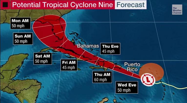
Potential Tropical Cyclone Nine was expected to mature to Tropical Storm Isaias late Wednesday or early Thursday on a path that swipes Puerto Rico, and ambles over the storm-rending peaks of Hispaniola and Cuba, before plopping into the Florida Straits.
A shaky timeline built around a “more uncertain than usual” forecast, would put tropical-storm-force winds on the doorstep of southeast Florida as early as Friday night and reach into Central Florida early Saturday.
At 2 p.m. Wednesday only the western edge of Florida’s Panhandle was outside the National Hurricane Center’s cone of uncertainty.
Robert Molleda, the warning coordination meteorologist for the National Weather Service in Miami, said Saturday morning is the more likely arrival time for damaging winds to the southern tip of the Peninsula with Central Florida beginning to feel the system’s bluster around 8 p.m. Saturday.
“I expect this will change, and may change quite a bit,” Molleda said. “It could be subject to major changes.”
The official NHC forecast keeps the system a tropical storm with maximum sustained winds reaching 60 mph early in its lifespan, then fading to 45 mph near the Florida Keys.
But areas far afield of the forecast cone will feel the effects of the system with tropical-storm-force winds extending 275 miles to the north and northeast.
The system could bring rain of up to 3 inches to the Treasure Coast through the Keys on Saturday and Sunday, but the National Weather Service was reluctant to lock in that prediction.
“We should be planning for tropical storm conditions,” Molleda said. “We need to talk about the potential for wind and rain and tornadoes, and maybe storm surge, but those may not be a factor at all.”
The challenge Wednesday was finding the key defining characteristic that would turn the slop of thunderstorms into a tropical cyclone – a well-defined closed-circulation center. While the system was packing tropical-storm-force winds of 45 mph at 2 p.m. Wednesday, there was no closed center.
Without a well-defined center, it is difficult to predict the track and intensity of the system.
“The forward speed of the system, dry air and wind shear are inhibiting the development of a closed low level circulation,” said Dennis Feltgen, a meteorologist and spokesman for the National Hurricane Center. “PTC Nine still looks like it will come together as a tropical storm later today or tonight.”
As of Wednesday afternoon, tropical storm warnings were in effect for pearls of terra firma from the Leeward Islands through the southeastern Bahamas, including parts of the Dominican Republic and Haiti.
The system was expected to move near or south of Puerto Rico on Wednesday, near or over Hispaniola on Thursday, and near or over eastern Cuba on Friday. Those islands have storm speedbumps such as 10,000-foot Pico Duarte in the Dominican Republic, and 6,500-foot Pico Turquino in Cuba.
“Simply put, there are a lot of hurdles in the systems’s way, so it is best to stay on the conservative side at the moment and continue to stress the large uncertainty after it leaves the Caribbean,” said NHC senior hurricane specialist Eric Blake in a forecast early Wednesday.


Add new comment